1-7 of 7 results
-
Graphics Tools for Meteorology Research and Education
PI Mark Sinclair
A software package called MADS (Meteorological Analysis and Diagnostic Software) is being developed to provide gridded data (both archived and real-time) and graphical software to produce maps, cross-sections, vertical profiles, time series graphs and statistical (climatological) displays of a large number of basic and derived quantities.
Unlike similar proprietary software products, MADS is intuitive and very easy to use. Students produce publication-quality color maps and graphs with only a few minutes of instruction and typically remark on how easy the software is to use. Meteorology faculty have used MADS plots for their research, and MADS assignments have been implemented into meteorology classes. MADS is ideal for institutions with limited computing support and is maintained by various automated scripts that download or update archived datasets. This system is continually being enhanced to accommodate more and more features expected in a modern meteorological graphics display package.This project has the potential to enhance meteorology education. Weather analysis and forecasting require both critical thinking and three-dimensional spatial analysis skills to apply complex theory to the diagnosis of atmospheric processes from multiple environmental variables in a variety of graphical formats. Outside websites used by meteorology students to visualize atmospheric fields typically offer a limited menu of “standard” meteorological displays. Upper-division theory classes are usually taught from a purely mathematical standpoint, with limited application to real-time atmospheric phenomena. MADS allows students to visualize contributions of the individual terms in dynamical meteorology or thermodynamics equations and overlay them to see their relative impact in the current meteorological context.Categories: Faculty-Staff
-
Ice Cloud Parameterizations and Aircraft Icing
PI Dorothea Ivanova
Ice and mixed phase clouds have an important impact on aviation, but they are often poorly represented in the models.
This proposal seeks to help improve our understanding of aircraft icing occurrence through better parameterizations of the ice microphysical cloud properties. The goal of this proposal is to create a new Global Climate Model (GCM) parameterization for Arctic ice and mixed-phase clouds, and explore possible relationship between different type size distributions (SDs), and airplane icing. The study will utilize data for different ice crystal size spectra in arctic cold clouds, and data for the corresponding airplane icing occurrences. The PI has already developed and published parameterizations for mid-latitude and tropical ice clouds (Ivanova 2001, Ivanova 2004, Mitchell and Ivanova 2006, Mitchell et al. 2008). The tropical and mid-latitude schemes predict different behavior of the SDs for the same ice water content (IWC) and temperatures. As temperature decreases beyond -35C, the concentration of the small crystals is enhanced with the tropical scheme, but the opposite occurs with the mid-latitude scheme. This finding indicates that the microphysics properties of tropical and mid-latitude cold clouds are considerably different for the same IWC. It may also point to the different mechanisms by which convective and non-convective cold clouds are generated. Clearly, there is a need for Arctic and polar ice cloud parameterization, and for a study to explore the possibility of a relationship between the environmental conditions (temperature, IWC, supercooled liquid water content), different predicted size spectra, and aircraft icing. Cold cloud interactions with aircrafts that fly through them require knowledge of cloud microphysics. Aircrafts must be designed to fly into supercooled clouds, or they must avoid those clouds in order to prevent problems associated with airframe and engine icing. De-icing or anti-icing systems must be engineered to withstand reasonable extremes in terms of ice water content (IWC), supercooled liquid water content (LWC), ice particle size distributions (SDs), and temperature. The aircraft design or certification envelopes (FAR 25, Appendix C; Federal Aviation Administration, 1999) were developed before the advent of modern cloud physics instrumentation. In the case of ice and mixed-phase clouds, data from the new arctic field campaigns suggest that cloud temperature is one of the main parameters governing cloud microstructure, the size distributions, and ice water content affecting aircraft icing. Korolev et al. (2001) showed that the cold cloud size distributions may depend on the value of the ice particle size assumed. Parameterizations of ice particle sizes for mid-latitude and tropical ice clouds (Ivanova et al., 2001, Boudala et al., 2002; Ivanova 2004; Mitchell et al., 2008) appear in recent literature, and were implemented in the U. S. Community Climate model 3 (CCM3) Global Climate Model (GCM), and U.K. MetOffice GCM, but little is done to study high latitude cold clouds size distributions and how they may be related to the aircraft icing.Contact Information
Categories: Faculty-Staff Undergraduate
-
Mesoscale Computer Modeling of the North American Monsoon over Arizona
PI Dorothea Ivanova
The Department of Meteorology is involved in research on the North American (Mexican) Monsoon in Arizona and the U.S. Southwest.
The objectives of this project are:- To achieve a better understanding of the evolution of the North American monsoon system and its variations.
- To achieve a better understanding of the response of warm season atmospheric circulation and precipitation patterns to slowly varying boundary conditions (e.g. sea surface temperatures—SSTs, soil moisture), using advanced computer models.
- To run atmospheric mesoscale models (MM5 and WRF) utilizing the parallel-processor supercomputer on the Prescott Campus.
Contact Information
Categories: Faculty-Staff
-
Cbud Computing for Meteorology Education
PI Curtis James
Weather analysis and forecasting require both critical thinking and three-dimensional spatial analysis skills to apply complex theory to the diagnosis of atmospheric processes from multiple environmental variables in a variety of formats.
Existing websites used by meteorology students to visualize atmospheric fields are not designed to facilitate synthesis of weather information because they offer a limited menu of “standard” meteorological displays without pedagogical intent or clear reference to theoretical underpinnings. Thus, there exists a significant opportunity to enhance online weather visualization tools in the context of meteorology education. This project seeks to create a virtual online LINUX server using a cloud service provider for 4D weather analysis and visualization in real time. University Corporation for Atmospheric Research's (UCAR's) Unidata will configure the server using the Local Data Manager (LDM), a prototype installation of AWIPS II standalone EDEX server and CAVE client, and a RAMADDA server. Other meteorological tools will be configured for real-time use by National Weather Service meteorologists and the Department of Meteorology. All of these software packages will be accessible from any computer or mobile device using a web browser, and will support the Department's new focus in Emergency Response Meteorology practices and applications.
Contact Information
Categories: Faculty-Staff
-
Wingsuit Aerodynamic Performance Measurement and Design Improvements
PI Timothy Sestak
Wingsuit flight and wingsuit design is in its pioneering stages. Development of wingsuits with regards to aerodynamics is rudimentary, and has been done primarily by a process of trial and error, and lacks solid aerodynamic foundation. A wingsuit is essentially a ram-air inflated airfoil structure with a human pilot inside.
This research proposes a phased exploration of 1) the measured performance of current wingsuit technologies and 2) an investigation of basic changes in materials and construction that have the potential for significant improvements in lift and drag, resulting in increased glide ratios. Initial research will take place in the ERAU Prescott Campus, subsonic - closed circuit, 32” x 45” wind tunnel. The first phase of this research will test, record, and compare the effect on performance of various materials and fabrics currently used by wingsuit manufacturers on a well-documented rigid airfoil shape and a typical wingsuit airfoil. Materials tested will include typical woven fabrics commonly used on current wingsuit designs and more exotic materials like laminated X-ply reinforced monofilm commonly used on windsurfer and competitive yacht sails. The aerodynamic effects of contaminated airfoils vs smooth surfaces is well known but there is little documentation concerning the use of fabric on wing surfaces and of airfoils of the size, operating speeds and Reynolds numbers of typical wingsuit sized airfoils. Many wingsuits use fabrics and materials believed to be poor aerodynamic choices or improperly positioned on the airfoil for best performance. Phase One will establish a baseline of data to empirically demonstrate and compare the effect of typically used materials and potential alternate materials on wingsuit airfoil performance. This will provide baseline data for following studies. Phase Two will repeat the performance data collection of phase one using ram-air inflated wing configurations similar to those used in current wingsuits. The lift and drag performance of typical ram-air wingsuit airfoils and the effect on lift and drag of differing materials used to construct ram-air inflated airfoils will be measured. Phase Three will examine the effects of wing deformation due to in-flight dynamic pressures. Then techniques for stabilization of wingsuit lifting shapes and surfaces to counter deformation by dynamic pressure will be examined. This phase will include the human factors elements of designing wingsuit components that are flexible, allowing a full range of motion to the human pilot necessary to safely fly the wingsuit and then deploy and operate a parachute for landing, while being aerodynamically stable and able to retain aerodynamic shape at high dynamic pressures. Phase Four will use the information developed from the previous research to explore a range of airfoil and membrane wing configurations both with Computational Fluid Dynamic (CFD) modeling and wind tunnel testing to derive human factors compatible wingsuit configurations that offer significantly improved performance over current designs. Significant human factors constraints exist in developing new concepts for wingsuits. The final concepts/products must be able to perform on a human worn suit, capable of donning and doffing in a reasonable amount of time, and while being worn enable the wearer to walk to, board, and safely exit while in flight, a typical aircraft used for skydiving (i.e. Twin Otter with inflight jump door) without unusual discomfort or the need for special accommodations. For manufacture and production, materials and processes must be compatible with customization to the body sizes of the full spectrum of wingsuit users. The final product must be able to be manufactured in a reasonable amount of time and cost, be durable enough to last for approximately 500 normal use flights without repair or unserviceable wear, and be affordable to the customer within the current range of wingsuit costs ($1500 to $2500 for a custom made, fit to the individual, high performance wingsuit). In this work we intend to use the significant previous work performed concerning ram-air inflated wing aerodynamics and high performance sail and membrane wing aerodynamics. Previous work is mostly at much lower airspeeds and with larger surfaces and Reynolds numbers than wingsuit aerodynamics, but should offer significant clues toward useful paths of research. CFD analysis software designed for high performance nautical sails will be a candidate technology to model and analyze potential designs to compare against wind tunnel testing of proposed modifications. Follow on research would involve incorporation of the resulting concepts into full sized wingsuits with wind tunnel and inflight testing. Collapsible ram-air airfoils developed for this study are also applicable to Unmanned Aerial Vehicle (UAV) operations, reducing the size of pre-deployment wings and the necessity for large bulky transport and storage. Follow on research will seek funding for applications of this technology to UAVs.Categories: Undergraduate
-
CONVECT (Convective Organization aNd Venting Experiment in Complex Terrain)
PI Curtis James
CO-I Ronny Schroeder

CONVECT is a major meteorological field research project being proposed for July - August 2025 in north-central Arizona. The project is aimed at improving our understanding and ability to predict the convective development and organization of boundary layer thermals, thunderstorms, and mesoscale convective systems during the North American Monsoon (NAM).
The proposed field project is the Convective Organization aNd Venting Experiment in Complex Terrain (CONVECT), focused in north-central Arizona near the city of Prescott. This targeted region, encompassing the Black Hills, Verde and Prescott Valleys, and Mogollon Rim, provides an ideal laboratory for investigating processes connecting complex terrain to boundary-layer and convective processes. During the summer monsoon season, this region experiences frequent deep, precipitating convection. These storms typically initiate over the most prominent terrain features in this region and then may propagate into the populated lower lying areas or send out density currents or buoyancy bores that subsequently initiate new convection. The thunderstorms are generally spatially localized, forming over a deep convective boundary layer, but are often associated with pulse severe conditions (damaging wind gusts or large hail). Some cells may become terrain-locked or exhibit back-building behavior, leading to intense rainfall and flash flooding.
The multi-scale approach proposed for CONVECT will, for the first time, capture the complete physical chain of land-atmosphere processes that drive water vapor transport and monsoonal precipitation over complex terrain at meso- to micro-scales. This diurnally cycling chain includes energy and moisture exchange over a heterogeneous, sloping surface, thermally-driven planetary boundary layer (PBL) circulations, the venting of PBL air into the free troposphere, and the initiation, upscale growth, and propagation of deep convection. The proposed deployment includes a dense network of surface flux and energy balance probes, lower-tropospheric thermodynamic and kinematic profiling systems, mobile radars, and crewed and uncrewed aircraft with in-situ and remote sensors. The campaign will be carefully guided by multi-scale modeling, and in turn, experimental observations will be assimilated to evaluate their impact on multi-scale predictability and the validity of surface layer and PBL parameterizations in complex terrain. The CONVECT science team of instrument scientists and numerical modelers contains the necessary, complementary expertise in the surface layer, the boundary layer, and deep convection to substantially advance understanding of mountain exchange between the surface and free troposphere, as well as extreme precipitation, through a multi-scale lens.
Categories: Faculty-Staff
-
ICARUS Drone Net
PI Samuel Siewert
CO-I Iacopo Gentilini
CO-I Mehran Andalibi
CO-I Stephen Bruder
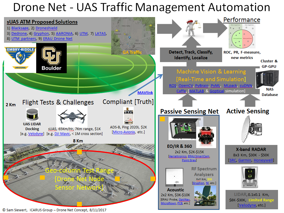
Drone Net is a conceptual architecture to integrate passive sensor nodes in a local sensor network along with traditional active sensing methods for small Unmanned Aerial Systems traffic management. The goal of the proposed research architecture is to evaluate use of multiple passive sensor nodes integrating Electro-Optical/Infrared and acoustic arrays networked around a UAS Traffic Management operating region (Class G uncontrolled airspace). The Drone Net approach will be compared to and/or used in addition to RADAR and Automatic Dependent Surveillance-Broadcast tracking and identification. We hypothesize that this approach can better manage non-compliant small UAS along with compliant UAS and general aviation in sensitive airspace, urban locations, and geo-fenced regions.
Drone-Net: Information Fusion Networks for Reliable Localization
ICARUS Research Group: ERAU Prescott
The challenge and opportunity presented by use of UAS “drones” in the national airspace (NAS) has historic significance not seen since the early days of aviation growth after the First World War. The FAA estimates that by 2020 the drone market will be $98 billion with 7 million drones added annually [1]. Market beneficiaries include industrial inspection, aerial photography, insurance, agricultural and government services [1]. While ADS-B for drones, along with registration, has been proposed as a quick fix, to allow drones into the NAS and to share populated areas, it is not clear how this will work for all types of drones ranging from professional service to hobby. For example, many drones will be fully compliant, but some may be semi-compliant (e.g., low quality position reporting due to degraded GPS), and others perhaps even totally non-compliant or hostile [2].
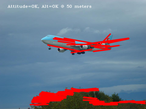
Embryonic research at ERAU Prescott to develop a drone detector, which can be placed on roof-tops and networked with other detectors and information services, has shown that multi-spectral EO/IR detection is quite effective. The feasibility of passive methods for civil aviation detection of aircraft not using ADS-B and not registered on flilghtradar24 [3] (via primary and secondary RADAR) has been experimentally observed.

The ICARUS group at ERAU Prescott is working to fly and test ADS-B on drones [9] that are compliant, semi-compliant, and non-compliant in order to evaluate methods of detection, classification and identification. Research by Sandia National Labs has shown that drones typically have very low RADAR cross-section area, similar to stealth aircraft [4] and can present a significant security and safety threat. The risk is that even one or two national security incidents involving service drones, hobby, or terrorism could result in the grounding of all drones in the NAS.
Multiple studies [4, 5] have substantiated the conclusion that no single sensing modality will suffice to reliably detect and localize a wide variety of drones. To this end, the ICARUS group proposes to pursue a heterogeneous information fusion approach with passive EO/IR and progressing to a “richer” passive/active sensor suite. Prior ICARUS research partially funded by DHS ADAC Center of Excellence (CoE) led to development of the SMDSI (Software Defined Multi-Spectral Imager) to detect and track marine traffic [6, 7]. This existing hardware will be adapted to accommodate additional sensors including acoustic, ADS-B, primary/secondary RADAR, and LIDAR in order to accelerate the development of optimal methods of drone detection, classification, and identification.
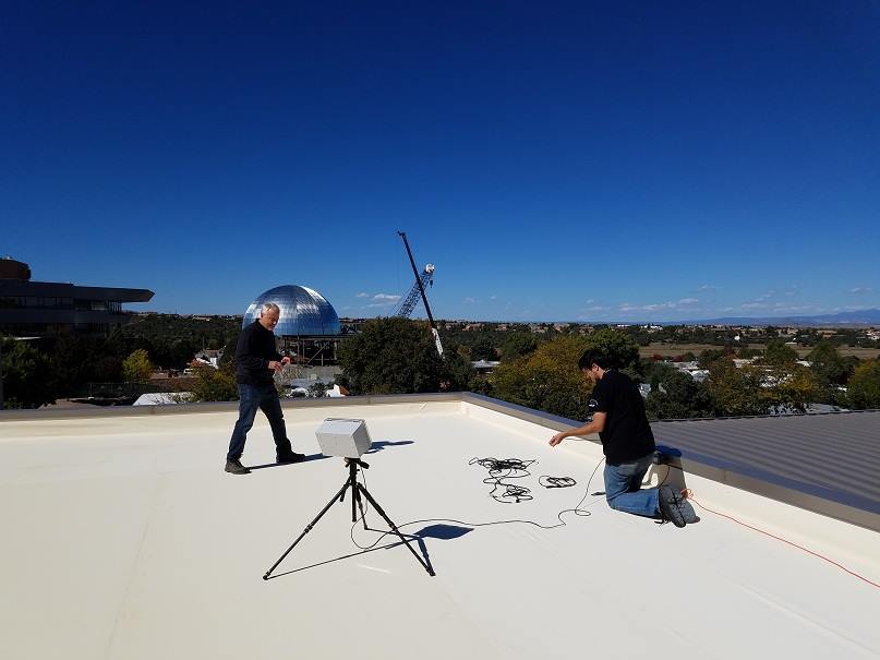
The first year of this proposed effort, will involve basic research in machine learning, machine vision, real-time systems, and the development of suitable information fusion algorithms, continuing through the duration. The test configuration will be documented to facilitate replication at other participating academic research organizations (ERAU Daytona ASSURE [11], U. of Alaska ACUASI [12], U. of Alaska DHS ADAC, and U. of Colorado Boulder Embedded Systems Engineering) in year two of the proposed research. Each collaborator can provide unique synergy to enhance research objectives and are potential future external funding partners. The team will include ERAU Prescott faculty, undergraduate students, CU Boulder graduate ESE students, and collaboration with faculty at U. of Alaska and Colorado. In the third year of work, passive capabilities can be enhanced with active LIDAR and existing RADAR at ERAU Prescott. The goal is to develop unique sensor fusion algorithms as well as machine learning and traditional salient object detection and classification methods.
The images collected over the lifetime of the project can further be saved in a distributed database of observed compliant, compliant-low-quality, non-compliant and perhaps hostile drones and shared between “Drone net” nodes. The overall vision is to create a network of passive/active drone detection, classification, and identification nodes to enhance security and safety for drone operations that surpasses ADS-B and registration alone [10]. The capability can be used to test and evaluate commercial drone detection systems being evaluated by the FBI at airports [8] and to make policy and technology recommendations to key agencies (FAA, DOT, DHS) for drone integration into the national air space. Drone net will enable ICARUS to pursue external funding from DHS CoEs, ONR (Office of Naval Research), NASA AIST (Advanced Information Systems Technology), FAA ASSURE, SBIR/STTR, and industry.
References
[1] FAA Aerospace Forecast, Fiscal Years 2016-2036, Federal Aviation Administration.
[2] How consumer drones wind up in the hands of ISIS fighters, Techcrunch, October 13, 2016.
[3] flightradar24.com, ADS-B, primary/secondary RADAR flight localization and aggregation services.
[4] Birch, Gabriel Carisle, John Clark Griffin, and Matthew Kelly Erdman. UAS Detection Classification and Neutralization: Market Survey 2015. No. SAND2015-6365. Sandia National Laboratories (SNL-NM), Albuquerque, NM, 2015.
[5] McNeal, Gregory S. "Unmanned Aerial System Threats: Exploring Security Implications and Mitigation Technologies." Available at SSRN (2015).
[6] Arctic Domain Awareness Research Center, U. of Alaska Anchorage, Theme 3, Task 2, SmartCam.
[7] S. Siewert, M. Vis, R. Claus, R. Krishnamurthy, S. B. Singh, A. K. Singh, S. Gunasekaran, “Image and Information Fusion Experiments with a Software-Defined Multi-Spectral Imaging System for Aviation and Marine Sensor Networks”, (in preparation) AIAA SciTech, Grapevine, Texas, January 2017.
[8] FAA Tests FBI Drone Detection System at JFK, Federal Aviation Administration, July, 2016.
[9] Micro-Avionix, Ping2020 ADS-B transponder for UAS.
[10] Rhode & Schwarz, Protecting the Sky - Signal Monitoring of Radio Controlled Civilian Unmanned Aerial Vehicles and Possible Countermeasures, October 2015.
[11] ACUASI, Alaska Center for Unmanned Aircraft Systems Integration, http://acuasi.alaska.edu/, Dr. Mike Hatfield.
[12] ASSURE, Alliance of System Safety for UAS through Research Excellence, http://assureuas.erau.edu/, Dr. Richard Stansbury.
Categories: Faculty-Staff
1-7 of 7 results
Contact Us
Prescott, AZ 86301